Mathematics has not always been the domain of scholars. In fact, there are many historical studies on mathematical practitioners and their methods. Why were people trying to use quantification and measurements in civil life? How were they doing it? Were these methods – especially for the early modern period – actually efficient?
Eva Germaine Rimington Taylor, in her pioneering 1954 study of British practitioners, showed that it is necessary to study surveyors, instrument makers and gaugers ‘as members of a group’, not as isolated individuals [1]. In her footsteps, Jim Bennett and Stephen Johnson underlined the importance of looking at the context in which this useful knowledge developed [2, p. 2]:
Mathematical practice … confounds disciplinary divisions between the histories of science, technology and mathematics. To take even a localised slice of mathematical practice seriously, and to investigate the identity of the mathematical practitioner, is an inherently interdisciplinary task.
The geometry used by early modern miners, which was necessary for the extraction of silver, cobalt and other precious metals at ever greater depths, offers an interesting and hitherto little-known example of practical mathematics [3]. Although navigators, mapmakers, barrel gaugers and even money changers are frequently studied, the disciplines of mining have largely stayed unexplored until recently.
However, mathematics was used extensively in extractive activities early on to answer the following types of question: How can we measure distances in sinuous tunnels? How can we determine the respective position of galleries?¹ How can we draw mining maps that allow us to ‘see through stones’? Finally, how can we plan and direct large-scale digging operations that routinely take decades to complete? After briefly sketching what subterranean geometry looked like, I will present some of the manuscripts used by practitioners.
Methods and instruments of a ‘mathematical art’
First, it is important to note that subterranean geometry was essentially a German discipline. While metallic mines existed in many countries, virtually all the experts – from those in the Potosi silver mines of the Spanish Empire to those working in the copper mines of Scandinavia – had been trained in German-speaking areas. This community developed its own language (Bergmannssprache) and even its own mathematical terms. The basis of a right-angled triangle was, for instance, labelled the sole, and its cathetus, the perpendicular depth – as such triangles were routinely used to compute the depth of galleries (Figure 1).

Their methods and instruments were not rooted in mathematical theories. Even the Latin tradition of geometria practica, which had developed in the medieval monasteries and universities, was unknown to them for a long time. Subterranean geometry evolved from a need to satisfy specific mining laws, including those that strictly stipulated the shape and length of mining concessions. The German name for ‘subterranean geometry’ literally translates to ‘the art of setting [concession] limits’ (Markscheidekunst). Oral customs, put into writing as early as the 13th century, describe how measuring ceremonies should be organised, who should make the measurements and how one should proceed.
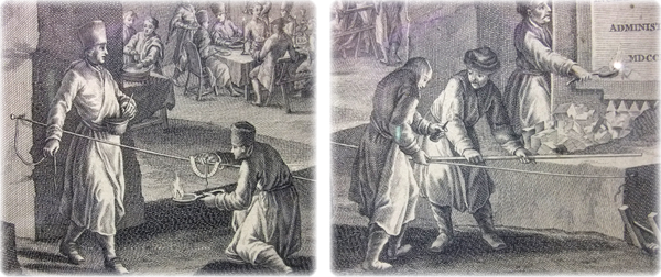
Surveyors did not use the abstract ruler and compass of Euclidean geometry, nor the astrolabe4 and Jacob’s staff of astronomers, but a cord, a compass and a semicircle. Both above and below ground, they generally assessed the pathways of galleries or ore veins by considering them as broken lines, using marks in stones or wood pickets to materialise the points. A semicircle suspended on a cord (Figure 2, left) gave the inclination, while a compass indicated the direction. Finally, the length of the segment would be measured, for instance, with a rod (Figure 2, right).
In medieval times, these measurements would simply be reproduced at the surface, perhaps on a frozen lake in winter, to visualise what was happening underground. As mining geometry progressed, practitioners gradually developed methods of drawing mining maps, on which problems could be solved directly, or they even used the raw data in the analytical computation of large-scale lengths and angles.
A manuscript tradition: Geometria Subterranea
The geometry used in mines, of which we have given here a very condensed view, grew increasingly complex over time. Its development did not unfold in response to theoretical challenges or abstract conjectures but to cope with very concrete problems that sometimes led to geometrical configurations. An interesting set of examples are the intersection problems: a mining company following an ore vein underground by digging a tunnel could claim a right over any other vein encountered within a square of 7 Lachter (a Lachter is roughly equal to a fathom or 1.8 metres) centred on the gallery. When two galleries met underground, the oldest one could claim its right over the younger, leading to the complex task of ascertaining where exactly the limit between them would be set: a schematic depiction of the problem can be seen in Figure 3.

Although a companionship system had long existed and was working efficiently under the control of the local mining administration, such problems could not simply be taught by trial and error. On the other hand, there were not yet any mining academies: the Bergakademie in Freiberg and the École des mines in Paris were not established until the end of the 18th century. As the need for a comprehensive mathematical education grew, training became more formal and based on the circulation of manuscripts. In the mining regions of Saxony and the Harz, official surveyors would write down the elementary arithmetic and geometry they needed, describe measuring instruments and their use, and then compile long lists of propositions. These were not theorems and problems in the Euclidean sense of the terms but concrete tasks to be carried out underground.
These fascinating texts circulated in manuscript form and were almost never published (one interesting exception being Nicolaus Voigtel’s Geometria Subterranea, oder Marckscheide-Kunst). They were self-contained objects that were copied from one’s master, improved during one’s career and then passed on to the next generation – or sold for handsome sums to foreigners aiming to improve mining in their own countries. They included trigonometric tables adapted to the unit systems used in mines and also case studies and examples in the form of data tables from previous operations.
These manuscripts are particularly interesting for historians of mathematics, as they are the product of an essentially practical tradition. Few mining surveyors were trained in theoretical mathematics, and those that were had mostly taught themselves. It is truly fascinating to see how new mathematical tools, for instance trigonometry, were appropriated and adapted by practitioners. These texts were mostly anonymous and often quoted passages from previous manuscripts and existing textbooks, such as parts of Euclid’s Elements and excerpts from various early modern treatises on instruments. Building on each other, the practitioners constantly expanded their manuscripts with new measuring data and more recent material. These texts thus document how practitioners thought and worked; together with the mass of administrative documents conserved in mining archives, they allow us to reconstruct precisely how subterranean geometry worked.
A visit to the mine
As a matter of conclusion, it might be interesting to ask how efficient and precise this practical geometry was. This is exactly the question that Jean André Deluc asked in 1777, in an article published in the Philosophical Transactions of the Royal Society [4, p. 424]:
But is this a method that may safely be depended upon? The fact answers, and saves us the trouble of long reasonings.
Deluc, fellow of the Royal Society and Reader to the Queen Charlotte, had travelled from London to the Harz mines in central Germany [4, pp. 401–402]:
These I knew were extremely deep; and it made me very desirous to try in them my rules for measuring heights by the barometer.
Unfortunately, he could not match his barometrical observations with direct depth measurements, as the mines were too hazardous a setting for a scholar. He shared with the captain-general of the mines, Baron von Reden, his frustration of not knowing the true distance between points in the mine, and the captain’s answer showed how trustworthy subterranean geometry was [4, p. 407]:
It is of much more consequence to us, than it can possibly be to you, to know exactly the depth of all the points of these mines. Without such knowledge, how could we direct ourselves in boring from one to the other?
As he got to know the mines and understand how the practitioners worked, Deluc was convinced [4, p. 424]:
I have observed some of these points of rencounter in the galleries; it is sometimes difficult to perceive the small winding which has been necessary for their meeting end to end.
Late in the 18th century, natural philosophers still needed mathematical practitioners, as their know-how was simply irreplaceable. In the 19th century, subterranean geometry then became part of the general education of mine engineers and ceased to be considered as a geometrical discipline.
In the early modern period, however, this ‘art of setting limits’ had fascinated generations of rulers and scholars. For modern historians of mathematics, the geometry of mining encapsulates the challenges and rewards of analysing how geometry and arithmetic were used, not only in theory but also in practice.
Thomas Morel
Bergische Universität Wuppertal
Notes
- In this context, a gallery is a subterranean passageway or mining system.
- Manuscript: Adam Schneider, c. 1669. Source: Universitätsbibliothek Freiberg, XVII 18.
- Copper engraving: J.G. Borlach and J.E. Nilson. Source: Universitätsbibliothek Freiberg, XVIII 1182.
- Astrolabes were instruments used in astronomy, astrology and navigation to ascertain the altitude of stars. Oxford’s History of Science museum has a great section on astrolabes.
- Source: Universitätsbibliothek Freiberg, XVII 18.
References
- Taylor, E.G.R. (1954) The Mathematical Practitioners of Tudor & Stuart England, Cambridge University Press, Cambridge.
- Johnston, S.A. (1994) Making mathematical practice: gentlemen, practitioners and artisans in Elizabethan England, PhD thesis, University of Cambridge Repository.
- Morel, T. (2022) Underground Mathematics: Craft Culture and Knowledge Production in Early Modern Europe, Cambridge University Press, Cambridge.
- Deluc, J.A. (1777) Barometrical observations on the depth of the mines in the Hartz, Philos. Trans. R. Soc. Lond., vol. 67, pp. 401–449.
Reproduced from Mathematics Today, April 2025
Download the article, Historical Notes: Subterranean Geometry (pdf)