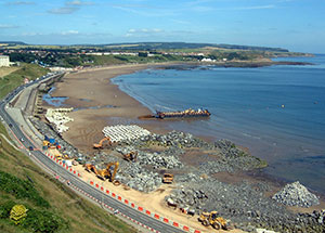
 Coastal erosion is a serious problem in the UK and currently occurs along 17% of the country’s coastline. The problem is worst in England, where 30% of the coastline is eroding, partly due to sea levels rising by 3 millimetres in each year since 1992. Erosion places homes at risk and can wash away sites of strategic and scientific importance, so understanding the processes at work is essential if we are to protect our coastline. Mathematicians such as Vanesa Magar and others at the School of Marine Science and Engineering at the University of Plymouth create models of these processes and use them to predict how erosion might occur and what effect introducing coastal defences will have.
Both short- and long-term processes are important when modelling coastal erosion, since small changes taking place over just a few hours can influence erosion over decades to come. These two very different timescales require different kinds of mathematics. Short time-term modelling is dynamic, using a variety of equations to predict the movement of water and coastal sediment, and the interactions between them. The exact model used depends on the particular properties of the beach being examined; in places with a low concentration of sediment the material has less of an effect on the water and the equations are easier to solve, but in high sediment locations the interactions between the two materials make finding a solution much harder.
The rate at which each equation changes is also an important factor. Water moves in constantly lapping waves, but changes in the coastline take much longer to occur. Determining how fast each equation in the model should be updated requires both skill and experience, especially since there is a limit to how fast the model can be – as the time between each update gets smaller, the computing power required increases.
Although these dynamic models provide a good understanding of the short-term processes at work, they can not be used to predict very far into the future since the equations become unstable. A similar problem occurs with weather modelling, where we can only make predictions a few days in advance. To get around this, mathematicians can examine the long-term processes of erosion with statistical methods based on data gathered from beach surveys. These methods aim to work out the long¬term evolution of a beach by extracting patterns from large amounts of data.
Magar’s research aims to analyse beach evolution at these different time-scales and bridge the gap between short-term and long-term models by adapting the dynamic equations used in the short-term to handle long-term processes. Using insights gained from beach data, it is possible to modify the model parameters so that the equations become more stable and possibly simpler for long-term predictions, but determining the effectiveness of long-term models requires continued evaluation of a beach over a long period of time, which is only possible with long-term investment of resources.
Both types of model provide information used by coastal managers and county councils to identify areas at risk of erosion and to create strategies to combat it. These include building long structures known as groynes at right angles to the coastline to prevent sediment from drifting down the beach, or beach nourishment, in which lost sediment is replaced by material from elsewhere. Port authorities can also use modelling data to consider the future properties of a port and determine whether navigation channels will remain accessible or require dredging in the future.
 These practical situations are normally analysed by coastal erosion consultants using a range of commercial software packages. The work of Magar and others feeds in to these packages, allowing them to handle new and unusual situations. Much of the coastal erosion software available is designed to model erosion in the sandy beaches found in the majority of the world, but the UK has mostly gravely beaches where the individual beach particles are roughly 10 times larger than sand. Because of this, the methods used to analyse sandy beaches need to be adapted to accurately model the uniquely changing coastline in the UK, and contributions from UK mathematicians are essential.
A greater understanding of coastal erosion will help us to protect important coastal regions and ensure people’s homes and businesses remain safe. The damage to our coasts is already extremely serious in some areas of the country, with coastal homes in Norfolk at such great a risk that they are being valued at just £ 1, and the expected increase in storm levels due to climate change will only worsen the situation.
Thankfully, the work of Magar and her colleagues promises to improve coastal defences and fight back against the tide.
Technical Supplement
Dynamic models
The complex mixture of water and sediment involved in coastal erosion means that a number of equations are needed to model the situation. Several models may be used to analyse the flow field as well as the sediment dynamics and the evolution of the seabed and the coastline. The shallow water model is commonly used to describe the hydrodynamics; this model is obtained by depth integrating the Navier-Stokes equations, effectively removing the vertical velocity from the equations. This is possible in the nearshore where the depth of the water at the coast is much smaller than the horizontal distance out to sea, and conservation of mass implies that under these conditions the vertical velocity of the fluid is small. Sediment movement is modelled with a separate set of sediment transport equations, and another equation describes the changing level of the ocean floor.
In general all these equations need to be solved simultaneously, but the timestep used to update the velocity field is much smaller that the timestep of bed level updating. In situations where the sediment concentration is low it is possible to first solve the shallow water equations and then use the result to solve the sediment transport equations, before finally solving the bed level equation for the ocean floor.
Statistical models
Data gathered from field surveys can be used to build statistical models that analyse the evolution of a beach in the long-term. Vanesa Magar and other mathematicians use functional data analysis to identify patterns within the data and link them to beach characteristics. These characteristics include ridges of sand known as sandbars that form just off the coast, or the beach berm, the horizontal portion of the beach. The future evolution of these patterns can be examined in a number of scenarios by using a jackknife resampling technique to vary the data in a realistic way.
References
Jamal, M. H., Simmonds, D., Magar, V. & Pan, S. (2010) Modelling Infiltration on Gravel Beaches with an XBeach Variant. 32nd International Conference on Coastal Engineering (ICCE 2010), Shanghai, China, June 30 – July 5, 2010.
Martin-Grandes, I.,Kingston, K., Simmonds, D. J., Davidson, M., Reeve, D. E. & Magar, V. (2010) The berm- bar dynamics of a composite beach. 32nd International Conference on Coastal Engineering (ICCE 2010), Shanghai, China, June 30 – July 5, 2010.
Reeve, D. E., Horrillo-Caraballo, J. M. & Magar, V. (2008) Statistical analysis and forecasts of long-term sandbank evolution at Great Yarmouth, UK. Estuarine, Coastal and Shelf Science, 79(3), 387-399. DOI: 10.1016/j. ecss.2008.04.016.
van der Werf, J. J., Magar, V., Malarkey, J., Guizien, K. & O’Donoghue, T. (2008) 2DV modelling of sediment transport processes over full-scale ripples in regular asymmetric oscillatory flow. Continental Shelf Research, 28(8), 1040-1056. DOI: 10.1016/j.csr.2008.02.007.
EPSRC Grants
Reference: EP/D507839/1
Title: Mathematical Methods for Coastal Engineering
Reference: EP/C005392/1
Title: A Risk-based Framework for Predicting Long-term Beach Evolution
Reference: EP/C508750/1
Title: Academic Fellowship in Coastal Morphodynamics
The IMA would like to thank Dr. Vanesa Magar, University of Plymouth for her help in the preparation of this document.


