Flooding is one of the biggest concerns of many communities, with about 5.2 million properties (one in six) in England alone being at risk. To address this problem, local communities are investigating low-cost nature- based flood defences such as planting trees, creating temporary storage ponds on land, and creating so called leaky dams. These types of solutions are extremely appealing as they are individually cheap to install and can often be put in place by community groups without the need for large-scale investment. Whether these flood- mitigation measures can be scaled up to have an impact on extreme flooding is, however, a topic of hot debate.
Leaky dams are usually constructed using semi-engineered stacks of logs across a channel, in a similar way to how a beaver’s dam is constructed. There is currently limited evidence on the effectiveness of this type of leaky dam, and there are potential pitfalls which need to be assessed and mitigated against. For example, if one leaky dam fails then there is a chance that it could cause a surge of water, which then causes another to fail further downstream. This is called a cascade failure and could trigger significant flooding, if a number of dams fail in succession.
In another scenario there is the possibility that placing dams on different tributaries could cause the peak flows of those tributaries to become synchronised causing a larger peak flow downstream. There is also the danger that leaky dams become damaged over time, or that during flooding, they simply don’t hold back enough water in the first place, rendering them ineffective.
Another problem is known as ‘upscaling’. This means that if there is a city which has a large catchment area, then you will need a lot of leaky dams in order to prevent or lower the flood in that city. You will need to scale up all the local efforts for their cumulative effects to make a difference. Despite these challenges, leaky dams have potential in offering low-cost flood protection, however we need to understand more about where they should be placed and in what number, to avoid the problems of cascade and synchronisation failures, and upscaling.
The leaky dam problem was studied as part of an Environmental Modelling in Industry Study Group held at the Isaac Newton Institute in Cambridge by the UK EPSRC Living with Environmental Change network called “Maths Foresees’’. Over the course of four days academic mathematicians, engineers and environmental scientists worked with researchers from industry to examine the impact of leaky dams on towns downstream. The leaky-dam challenge was put forward by JBA Trust and was one of the five challenges on flooding put forward by UK stakeholders.
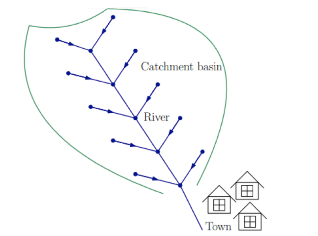
The group tackled the problem by breaking it down into a simple network model. This meant stripping out any information about the lie of the land or the surrounding terrain and looking at the basic structure of the system and how water flows through it.
There are some big advantages to using a simplified model, one of which is that it helps to give a picture of the general behaviour of a system, in this case allowing the researchers to examine where the leaky dams should be placed so as to minimise flood risk to the town downstream. The simplicity of the model meant that thousands of computer simulations could be performed, each with different possible weather conditions or modes of failure. In such a simple model, it is easy to experiment with different scenarios such as changing the lengths of the tributaries and positions of the leaky dams.
A number of key patterns quickly emerged, such as the importance of placing lots of leaky dams in order to achieve any noticeable effect, and the fact that the most effective barriers needed to be higher up in the water-catchment area. The researchers also examined the worst configurations, which included placing the leaky barriers on the main trunk. They discovered that this could more frequently lead to a cascade failure, with a peak flow an order of magnitude (i.e. 10 times) greater than when the barriers were placed on the tributaries.
This initial research has provided some useful pointers, particularly for community groups who want to build this type of natural flood defence. It will help them to avoid building barriers which do not have much beneficial impact, or in places with the potential for cascade failure and worsened flooding.
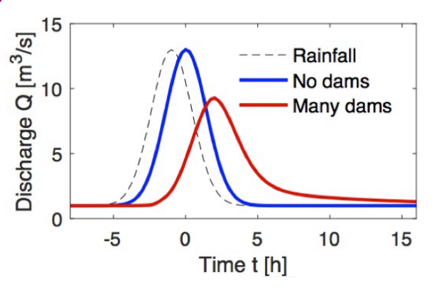
In the future, the researchers want to build on this research by looking at a more detailed model which could include additional risks such as the dangers of debris from the leaky dams causing further blockages downstream. They also plan to look at an optimisation problem, where they include the cost of building the leaky dams, and weigh the benefits against the costs to determine the best solution. It is never possible to fully eliminate the risk of flooding entirely. An optimisation model will examine the most cost- effective solution that produces a specified level of risk, such as limiting the likelihood of flooding in any one year to be no more than 0.5% (or less in cities), as recommended by the National Infrastructure Commission.
Technical Supplement
In the network model in Figure 1, water flows down the tributaries, and is eventually channelled into the main trunk river where it then passes through the town. The researchers need to know the volume of water passing through the town at any one time, as this translates into a water depth and determines whether the town is flooded or not. In order to calculate the volume of water in each segment of river through time they use the
following set of differential equations:
![\[\ell_{i} \frac{\mathrm{d} A_{i}}{\mathrm{~d} t}=\sum_{j=1}^{N} a_{j i} Q_{j}-Q_{i}+q_{i},\]](https://ima.org.uk/wp/wp-content/ql-cache/quicklatex.com-792bd5c00af2f9bcba78c49ddd2c246f_l3.svg "Rendered by QuickLaTeX.com")
The left-hand side of the equation represents the rate of change with time of the volume of water in a segment  of a river, because it is the length of the segment
  multiplied by the rate of change in cross-sectional area
  . This volume is influenced by three different things.
 is the flow of water into the segment from any upstream segments and
  is the flow of water out of the segment. The term
  represents any other input of water such as rainfall and run-off from surrounding land. This equation helps the mathematicians to answer the all-important question about how much water leaves the final segment and flows towards the town.
Note
The IMA would like to thank Ian Hewitt, University of Oxford and Barry Hankin, JBA Trust for their help in the preparation of this document.
References
www.turing-gateway.cam.ac.uk/sites/default/files/asset/doc/1803/jba_final.pdf
www1.maths.leeds.ac.uk/mathsforesees/
Image credit: File:Dülmen, Naturschutzgebiet -Franzosenbach-, Strotbach — 2014 — 0029.jpg by Dietmar Rabich / Wikimedia Commons / CC BY-SA 4.0